

Kingman Minerals (TSXV: KGS) this morning provided shareholders with their second update in a three part series related to its Mohave Project, located in the Music Mountain region of Mohave County, Arizona. The project consists of 20 lode claims, which includes the historic Rosebud Mine.
The property itself hosts eight separate veins as well as one double vein in addition to the Rosebud Mine, which extend from the northwest corner to the southeast corner of the property. Activity on the Mohave project dates back to the 1880’s, when high grade gold and silver was discovered on the property which was later mined in the 1920’s and 1930’s underground.
Underneath the surface at the Rosebud Mine, the project has a 400 foot shaft along with roughly 2,500 feet of drifts, raises and crosscuts. Veins at the 100, 200 and 250 foot level were mined, with much of the early mining done by lessees. While production figures for the property are very incomplete as per a 1983 report, some of the shipping ore from the mine was said to consist of anywhere from 15 to 20 ounces per ton gold, or 514.2 to 685.6 grams per ton gold.

Above the surface, in 1984 eight holes that totaled 473 meters were diamond drilled on the Southwick veins, which is where the main production shaft is located. The drill program was designed prospect for new deposits at a distance of 200 feet beyond the northwest end of the underground work, and was a part of underground and surface mapping and sampling conducted on behalf of Stellar Resource Corp between 1984 and 1986. Fifty of the 138 samples assayed showed greater than 3.429 g/t gold, with a high result of 436.697 g/t gold. The shortest hole from the drill program was at 106 feet, while the longest at 301 feet, with a total of 69 core samples analyzed for gold and silver.
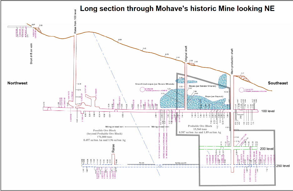
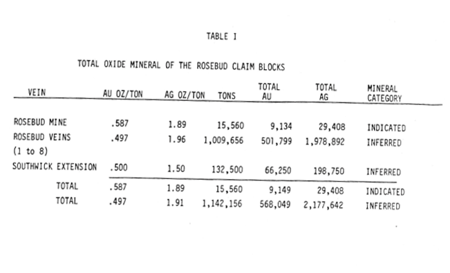
Results from the core samples were claimed to have discovered two new zones of grade mineralization, with significant results reported to include 4.286 g/t gold and 60.629 g/t silver over 0.79 meters at a depth of 48 meters, and 8.95 g/t gold and 26.64 g/t silver over 1.04 meters at a depth of 17 meters. The data from this resulted in the explorer, Bayrock, to estimate indicated mineral resources of 15,560 tons averaging 20.12 g/t gold and 64.79 g/t silver. Inferred resource for the eight known mineralized zones was stated to be 1,142,156 tons averaging 17.04 g/t gold and 67.19 g/t silver, however it should be noted that these figures are not NI 43-101 compliant. The total length of the individual veins was stated to be approximately 12,800 feet, while the tonnage of inferred mineralization showed potential for medium to large scale mining based on $317.42 per ounce gold.
FULL DISCLOSURE: Kingman Minerals is a client of Canacom Group, the parent company of The Deep Dive. The author has been compensated to cover Kingman Minerals on The Deep Dive, with The Deep Dive having full editorial control. Not a recommendation to buy or sell. Always do additional research and consult a professional before purchasing a security.


One Response
Some serious historicals.
Would love to see some updated results.